
")
")


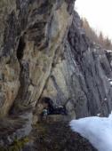
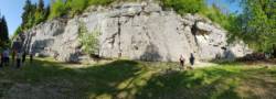
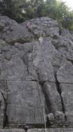
La Fauconnière (Franche-Comté)
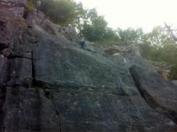

Interesting rock climbing area for routes up to 5c and from 6a to 6c (french grades).
Best time(s) :
- January
- February
- March
- April
- May
- June
- July
- August
- Sept.
- Oct.
- Nov.
- Dec.
Aspect(s) : E Altitude : 900 m
Approach 2 min on flat ground. Kids friendly ? foot of the crag comfortable for young kids.
Informations :
Between 50 and 100 routes, from 3a to 7b. Bolting : sport climbing
Max Height : 18 m.
Rock :
limestone. Characteristic(s) : overhang  , vertical
  , slab
  . Type(s) of holds : crimps, cracks.
Further information(s) : Site d'initiation dans une ancienne carrière. Le topo est disponible à l'office du tourisme de Pontarlier pour 4 €
Locations :
Area :
France, Bourgogne-Franche-Comté, Doubs (25), Besançon, Pontarlier.
|
|
Latitude : 46° 53' 37" N | Longitude : 6° 21' 29" E | Sexagesimal & Orientation |
|
|
Latitude : 46° 53' 38" N | Longitude : 6° 21' 32" E | Sexagesimal & Orientation |
| More coordinates |
Area added by CA

